Shortlisted in Projects / Public voting 2018:
High Water Channel Veessen-Wapenveld
www.veenenbosenbosch.nl
Projects / Projects 2018 / Netherlands / Built in 2017 /
![The Waaldijk between Gorinchem and Waardenburg (GOWA) has been reinforced over a length of 23 kilometres to meet current safety standards. The intervention adds a new layer to the river landscape, where flood protection, ecology, and public space are conceived as one integrated system. This holistic approach created space for a wider flow bed through […]](https://landezine-award.com/wp-content/uploads/2026/05/00_73566-Dijkversterking-GOWA-1-HERO-IMAGE-1-600x450.jpg "Dijkversterking GOWA")
![Mooi Mosterdhof: Comprehensive Neighborhood Renewal How do we prepare urban boundaries for the future? Panorama Lokaal was a design competition for creative teams interested in tackling this question, commissioned by local coalitions of municipalities, housing corporations, and other stakeholders. Seven locations throughout the Netherlands, neighborhoods from the 1960’s ‘70’s and 80’, were selected. Teams were […]](https://landezine-award.com/wp-content/uploads/2025/05/00-vb_main-photo.-green-wild-planted-courtyard-600x400.jpg "Mooi Mosterdhof by Veenenbos en Bosch Landschapsarchitecten")
![Blauwe Golven For years, Blauwe Golven was at the center of a heated urban debate in the city of Arnhem. Should this environmental artwork remain? Is it part of Arnhem’s identity, is it a monument? Is so much paved surface still appropriate in this day and age? Both residents and the local authority were divided […]](https://landezine-award.com/wp-content/uploads/2025/05/00-vb_main-photo.-overview-blauwe-golven-600x386.jpg "Blauwe Golven (Blue Waves) by Veenenbos en Bosch Landschapsarchitecten")
![The High Park project is about repurposing abandoned office buildings and healing the urban fabric. This is a challenge. Especially when dealing with a building from the brutalist era that has a rather defensive appearance and is engraved in the local, collective memory as such. It takes clever design to take down both the physical […]](https://landezine-award.com/wp-content/uploads/2024/05/00-vb_High-Park_planting-under-columns-600x450.jpg "High Park")
Problem
In January 1995, 250,000 people were required to evacuate from large parts of the Dutch river area due to the dangerously high water levels of the Rhine, Maas and Waal. As a result, from 2007 onwards, the government started an intensive cooperation with both regional and local parties in the Rhine river area on the Room for the River program. This program brings protection against flooding of the rivers up to a required standard. Special about the program is that this is largely done by redesigning and fortifying the river dikes, outer dike and inner dike areas in order to give the river more space.
Solution
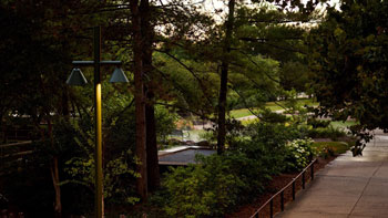
In the context of Room for the River a channel for high water has been realised between Veessen and Wapenveld. It is one of the largest and most effective projects realised for Room for the River, and the press already characterise the inlet as a new Deltawork. The channel provides space for the river during extreme high water, reducing water levels far upstream. The channel’s grounds have a continued agricultural use; therefore, it is designed according to a once-in-a-lifetime flooding threshold. The inlet consists of a large-scale valve mechanism, and the outlet has a fixed barrier with a sluice. A north and a south bridge provide access to villages along the riverbank during high water.
The route of the new dikes merges into the landscape. The dikes are on the transitions to the higher grounds, and the channel encompasses the spacious, open basin grounds. Following the path on the dike, it has markedly sharp turns, offering remarkable views of the surroundings. Along the west dike, a varied ‘landscape zone’ offers space for nature and also for a bike path, canoe route, and bird watching hut. The required structural works, from bridges to locks, are designed as one family: both understated and refined. The long inlet with its steel blades is combined with a bridge that can be used during high water. The pumping station is housed in a protective see-thru metal mesh.
Process
There has been resistance against the necessity and arrival of the channel. Nevertheless, an open planning process was chosen at the start of the entire process. At the beginning, principles were formulated with residents in the areas concerning liveability, agricultural development and spatial planning. First, four alternatives were identified, after which a preferred plan was formulated. A sounding board consisting of representatives of farmers, residents, nature organizations and entrepreneurs has strongly advised in this process.
Social en environmental effects
Together with the measures taken for the river, the overall development of the area has been set in motion. Because of the forced relocation and purchase of farms, the area could be redistributed, which has considerably strengthened the existing cattle farms. More opportunities for tourism and recreation have also been realized. The network of bicycle routes has been extended by more than 10 km, various rest points have been added along the routes and an information center has been set up. A new riverfront has been constructed for the village of Veessen, which is more suitable for recreation. The township of Vorchten is enriched with a community house next to its historic church.


Entrant office name: veenenbos en bosch landschapsarchitecten
Role of the entrant in the project: landscape architect Masterplan and Supervisor
Website: www.veenenbosenbosch.nl
Other designers involved in the design of landscape:
Lodewijk Baljon landschapsarchitecten (Supervisor and landscape architect),
ZUS [Zones Urbaines Sensibles] (Design structural works)
Project location (Street, City, Country): Veessen, the Netherlands
Design year: 2007 – 2012
Year Built: 2013 – 2017
Photo credits: Denis Guzzo, Harry Cock & Hans Snelleman
LILA 2026 Sponsor