Kapucijnenvoer
www.swecobelgium.be/expertise/urban.habitat
Projects / Projects 2018 / Belgium / Built in 2016 /

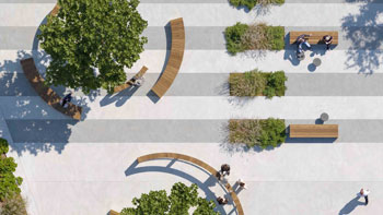
![Waregem, Rainbow Square A New Entrance for the City and Stadium Until recently, this space was merely an asphalt parking area, primarily serving the football stadium. With the arrival of an office building, a hotel, two apartment buildings, and the renovation of the football stadium, the site has undergone a complete transformation from single-use (parking) […]](https://landezine-award.com/wp-content/uploads/2025/05/00-_74A5798-600x400.jpg "Rainbow Square, Waregem by Sweco bv")
![The Nieuwstraat serves as an urban spine for the largest commercial hub in the Brussels Region and urgently needs revitalization. To address this, the city of Brussels commissioned a masterplan, offering a comprehensive vision of the city center project area, and a full study for the redesign of a commercial and public space. Various ongoing […]](https://landezine-award.com/wp-content/uploads/2025/05/00-10-dronebeeld-koolstraat-600x337.jpg "Nieuwstraat Brussels by Sweco bv")
![From village to dune The Princess of Seaside Resorts now offers not only its beautiful beaches but also a renovated dune area and a neighborhood park for young and old. Sweco has studied the public space, infrastructure, and climate adaptation and provided an accessible design for all ages. Wenduine has gained a beautiful public space […]](https://landezine-award.com/wp-content/uploads/2025/05/00-WENDUINE_MAIN-PHOTO-600x450.jpg "Wenduine, Neighborhood Park Benjamin – Spioenkop by Sweco bv")
![Introduction Wonderwoud is the name of the fourth green-pole of the city of Ghent. It is located on the eastern outskirts of the city, on approximately 7 km of the city center and it will be connected by a future green climate axe. The final green-pole will cover 100 hectares. The first phase includes the […]](https://landezine-award.com/wp-content/uploads/2025/05/00_WONDERWOUD-TOWER-©-Andy-de-Pourcq-600x384.jpg "Wonderwoud by Sweco bv")
![Forecourt be-MINE The Limburg Investment Company (LRM) is developing the old be-MINE mine site, which is 32 hectares in size, in Beringen. The site is being repurposed as a tourist-recreational project. Urban functions such as housing, work, shopping, and catering are interwoven in a balanced way. Not only are new functions accommodated on the former […]](https://landezine-award.com/wp-content/uploads/2024/05/00-Photography-by-Manu-Versluys-4-600x450.jpg "Forecourt be-MINE Beringen – Limburg")
![The Market as a parking lot
The former Market of Gavere mainly served as a parking lot. The pavement was diverse and in very poor condition, and there was no space to meet or stay. Pedestrians only had a meager sidewalk along the facades… Transformation In the redesign of the public space, and especially in […]](https://landezine-award.com/wp-content/uploads/2024/05/00-MARKT-03_AFTER-600x400.jpg "Markt Gavere")
![An old branch of the River Jeker had become derelict and covered in the past. The city of Tongeren had the ambition to make the old historic riverbed visible and tangible again. Our aim for the project was to use the disclosure to reconstruct the former river valley within the city and add new value […]](https://landezine-award.com/wp-content/uploads/2024/05/00-SWECO_TONGEREN_DEMOTTEN_DRONE-00047-600x337.jpg "Renovated city park ‘De Motten’ with disclosure of the River Jeker in Tongeren")
![The Rives Ardentes project is an ambitious initiative aimed at transforming a former industrial site into a model eco-district for sustainability and urban innovation. This project is a result of Liège’s bid to host an international exhibition in 2017, where the site of Coronmeuse was chosen as the location for the expo. Although Liège was […]](https://landezine-award.com/wp-content/uploads/2024/05/00-SWECO_Coronmeuse_HRes-7878-600x401.jpg "Eco-Quartier Coronmeuse: Rives Ardentes")
![The public space of the Kievit neighborhood serves as international oriented entrance area of the well-known Central Station of Antwerp, as an urban work-and living place in this city quarter and as a leisure area for locals. Therefore the design team BUUR-HOSPER takes a strong identity as paramount in the design: as recognizable binding figure […]](https://landezine-award.com/wp-content/uploads/2024/05/00-202306-Kievit-02-foto-Tom-Dhaenens-400x600.jpg "Public space Kievit neighborhood, Antwerp")
![Sweco plans and designs the communities and cities of the future. The results of our work are sustainable buildings, efficient infrastructure and qualitative industry & energy projects. With 14,500 employees in Europe (of which 1.000 in Belgium), we offer our customers the right expertise for every situation. Urban.Habitat brings together various expertise within Sweco Belgium: […]](https://landezine-award.com/wp-content/uploads/2018/05/Sweco-Urban.Habitat-office-photo-600x400.jpg "Sweco Belgium NV Urban.Habitat")
![Uniform village image The village centre of Roborst (Zwalm), located in the Zwalm valley, is still characterized by the historical coherence of the church square and castle grounds, with nearby motte. The undulating topography makes the location in the landscape very striking. Therefore, it’s also logical that in 1996 and 2001 protections were laid down […]](https://landezine-award.com/wp-content/uploads/2018/04/20170921_145527-450x600.jpg "Roborst")
![The centre of Kruishoutem, the ‘Markt’ (Market), the Nieuw Plein (New Square) and the surrounding streets are undergoing a thorough redesign of the public space and the construction of a separate sewerage system. The first phase, the Blekerijstraat, Nieuw Plein and Woestijnestraat, was finalized in the spring of 2017. In doing so, the weekly market […]](https://landezine-award.com/wp-content/uploads/2018/04/GOOTS_SWECO_Kruishoutem_HRes-60-600x297.jpg "Kruishoutem")
![A former railway yard with workshops along the L28 railway line has been designed as a multipurpose, public green area. For the most part, the park is on the territory of Sint-Jans-Molenbeek, with a small bit belonging to the city of Brussels. In addition to a residential and recreational function, it also has an important […]](https://landezine-award.com/wp-content/uploads/2018/04/GRONTMIJ_DuBrucq_HRES-7887-400x600.jpg "Park L28")
![Israel’s Square – the shifting identities
The location of Israel Square is rich in opportunities and stretches between two worlds: the bustling covered market where thousands of people pass every day and the lush H.C. Ørsteds Park, where the people of Copenhagen enjoy the green space in the middle of the city. Israel’s Square is placed […]](https://landezine-award.com/wp-content/uploads/2017/07/Rasmus-Hjortshoj-Israels-Plads-36-600x391.jpg "Israel’s Square")
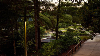
The historic Voer, a tributary of the Dijle, has been reopened again after more than a century of being covered. The Kapucijnenvoer is now a pleasant, green place to be. The chaotic traffic situation has been tackled and a safe link has been created in the bicycle axis between the city centre, the students’ sports apartments and the Arenberg Campus.
The Kapucijnenvoer is located on the edge of Leuven city centre, where the Voer used to flow into the city and out into the Dijle. At the beginning of the last century, the river supplied water for the inhabitants and the industry of the city, until it became overgrown and made way for a meagre grass field. The Kapucijnenvoer eventually evolved into an important traffic axis to and from the city centre, owing to its location in the extension of the Boudewijnlaan, a connecting road to the E314. However, its implementation was chaotic and without much appeal. The poor condition of the “Voerkoker” (Voer tunnel) under the eastern roadway was the reason to start thinking about the site. This resulted in a concept for partially reopening the Voer and reconstructing the Kapucijnenvoer.The project combined various objectives: creating a clear traffic situation, making the Voer visible again in the townscape, improving water management and increasing the image value of the Kapucijnenvoer.
EXPERIENCE ON THE WATER
On the Kapucijnenvoer today, it’s all about enjoying views on the water again. The reconstruction has restored a historical element that refers to the urban and economic development of Leuven. The opened Voer has been shifted to the western line of façades. The relief difference was accommodated by creating a quay, which functions as a residential balcony for the row of houses. The upper and lower quays provide additional experiential value. Along the Voer, a central green park zone has been constructed under a gentle incline. For this, a small area has been removed from the traffic lane. At both ends, some intimate spots have been added under a few massive trees. A mineral space rounds off the tops. In the north, this space forms the transition to a narrower inner-city profile of the road.
A BEAUTIFUL ENTRANCE FOR LEUVEN
Moving the Voer from a tunnel beneath the roadway to an open position on the east side creates more experience in the quiet part of this wide space. The roadway has been moved to one side and on the side of the old slaughterhouse there is a wide walking and cycling lane. This creates an important link for vulnerable traffic. Along the water, a clear bicycle axis now runs from the city centre towards Arenberg Castle. The slightly deeper location of the waterfront creates a natural distance with the busy two lane road.
UNDER SUPERSTRUCTURE
The technical difficulty of the project manifested itself mainly in the substructure. The alluvial subsoil appeared to be sensitive to settling and beneath the less permeable upper layers with peat, the water bearing gravel layers were under tension. It took a lot of thinking to find a sustainable, technically and economically feasible solution for this. The quays are constructed of brick masonry, topped in Belgian bluestone and with a simple steel railing. The squares at the top are laid out in black basalt in mosaic format.
COLLABORATION
The project involved the City of Leuven, Aquafin, the Flemish Environment Agency (Water department) and the Roads and Traffic Agency. The sometimes conflicting wishes of all parties were combined in one coherent proposal. Much attention was paid to the participation of clients and other stakeholders such as De Lijn. Where possible, the social preconditions were anticipated, such as accessibility, phasing and nuisance limitation.


Entrant office name: Urban.Habitat_division of SWECO Belgium nv
Role of the entrant in the project: main contractor
Project location (Street, City, Country): Stad Leuven, Kapucijnenvoer, 3000 Leuven, BELGIUM
Design year: 2008-2010
Year Built: 2011-2016
LILA 2026 Sponsor