Kopaszi embakment – Lágymányosi bay – revitalization – waterfront design by Garten Studio Ltd.
gartenstudio.hu
2025 Entries / 2025 Revisited Landscapes / Hungary / Built in 2007 /

![The renewal of the world’s first people’s park: Városliget The park’s history spans over two centuries, beginning with Henrich Nebbien’s winning 1813 design, which embraced the romantic English garden style through winding paths, a lake with islands, and rural elements like a farm on Peacock Island. Although much of his vision was realized by the […]](https://landezine-award.com/wp-content/uploads/2025/05/00-Main-photo_Liget-600x449.jpg "Városliget park competition; Városliget park rehabilitation by Garten Studio Ltd.")
![For the iconic building of the Museum of Ethnography, the architects dreamed up a roof garden which is also connected to the ground level and can be freely walked in by all visitors to the City Park. In the development of the green areas, numerous special requirements had to be met besides the general criteria. […]](https://landezine-award.com/wp-content/uploads/2025/05/00-11-600x338.jpg "Museum of Ethnography – Liget Budapest Project – Hungary by Garten Studio Ltd.")
![The Csikós courtyard is the collective name for the open spaces on the western side of Buda Castle, between the level of Palota út and Hunyadi tér, between the Curtain Wall and the Palace’s ‘F’ wing. This area was re-connected to the circulation of the Castle Hill through the reconstruction of buildings and structures destroyed […]](https://landezine-award.com/wp-content/uploads/2025/05/00-1920_7-karakas-torony-ga-jpg-epiteszforum-30-2023-08-28-182802_fotó-Gulyás-Attila-copy-600x400.jpg "Csikós courtyard, Buda Palace District – Hungary by Garten Studio Ltd.")
![Barabás Villa – A Monument Rescued from Decay The design of the Barabás Villa garden is one of the earliest completed and still functioning projects of our landscape architecture office. Over 24 years ago, we were commissioned by the architect to create the plans for the villa garden, and we also closely followed the construction […]](https://landezine-award.com/wp-content/uploads/2025/05/00-barabas-villa-main-foto-600x400.jpg "Barabás Villa by Garten Studio Ltd.")
![Garten Studio Ltd. was established in 1995, by five landscape architects. In the beginning, our profile was landscape architecture, design and construction works too. Nowadays, the bureau consists of 24 designers. Our main profile is landscape architecture: design and environmental planning. MOTIVATION As landscape architects our goal is to find the potentials of a site. […]](https://landezine-award.com/wp-content/uploads/2020/04/V4_Garten-Studio-Team_corrected-6x4-600x600.jpg "Garten Studio")
![The playground is located in Városliget, in the heart of Budapest. It has been constructed through the Liget Budapest Project, in which Europe’s first public park is being reconstructed. The surrounding in itself, in which the playground got implemented, is exquisite, with a well-developed mature population of trees, perfect micro areas from full sun to […]](https://landezine-award.com/wp-content/uploads/2020/04/00-TGZ_3732-600x400.jpg "Városliget – Main Playground")
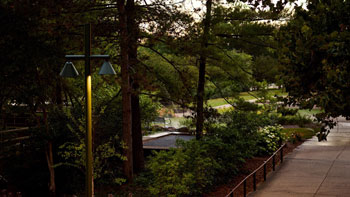
IN BUDAPEST, the Lágymányosi section of the Danube was regulated at the end of the 19th century, the river was squeezed between parallel dams, thus reducing its width from 1050 m to 380 m. The Kopaszi Dam is part of this parallel work. The filling of the floodplain area was completed with the construction of the Lágymányosi Bridge, but this was only partially done on its southern side, a significant part of the bay – the Lágymányosi harbor – remained. An architectural design competition was announced for this in 2004, the continuation of which was that our company, as a partner of the awarded architect who won the commission, was able to prepare the environmental planning plans for the 20 ha area.
The INVESTMENT covered the Kopaszi Dam and the coastal sections surrounding the water surface, which the Budapest Framework Plan defined as an area of special urban interest requiring special regulation, both due to its natural features and its place in the urban structure. Until recently, the area was a densely populated part of the city with industrial plants, and the underutilized, dilapidated buildings were used by business associations and sports clubs. The lush vegetation that spontaneously emerged on the shores of the bay over the past hundred years created a natural environment, but the trees overgrew and died without treatment. The appearance of the bay was not worthy of its status, and high-quality development was urged by common interest. The regulations provided an opportunity – in addition to preserving natural values - to build the infrastructure for larger investments, which created the economic basis for rehabilitation. The emerging private capital made it possible to create a high-quality architectural ensemble, during which the green development of the damaged area was given special emphasis.


The water level of the DANUBE fluctuates by 8.5 m, and part of the area is located outside the flood protection line. This duality necessitated the development of a complex system of considerations during the design, where the often conflicting needs and possibilities of technical content, function and aesthetic appearance had to be considered. During the design, we took into account the entire water movement, but treated the average height calculated from the water levels as a guide level, at which water level all functions of the coastal facility can be utilized to the maximum.
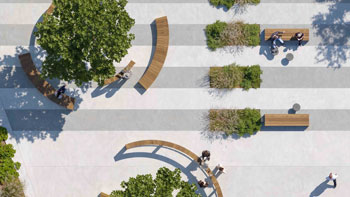
The entire coastal area of the BAY was part of the design. The developer expected us to create an environment created with modern spatial design tools, where the intensive use related to the new buildings would be maximally served, but the original atmosphere of the dam could also be felt. The area is characterized by its relative narrowness, therefore the functions, spatial structure and chain of objects are linear. The spatial elements connected to the line deliver and receive visitors in a row, who thus develop a complex, ‘pulsating’ spatial experience. The design of the environment also provides orientation, while the different characteristics are also suitable for characterizing the spaces.
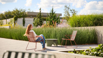
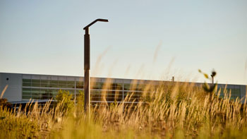
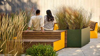
THE BUILDINGS are primarily catering units, as well as for sports and leisure activities. On the 2 km stretch of the shore, spaces with diverse designs and functions follow each other. The walkways weave the entire area in such a way that the park can be used and accessed at a wide variety of water levels. The movement of water was also decisive in the selection of plant material. In the sections with permanent water cover, we used the species of gallery forests along the Danube, while in the higher areas we could use a much wider variety of plants.
THE KOPASZI DAM is nearly 1 km long and 50 meters wide on average, its eastern side runs steeply down towards the Danube. 15 pavilion buildings were placed on the dam, and in line with these, we designed the wide promenade running along the dam and the wooden-covered footpath stringing the buildings in a “zigzag” line, which in some places rises from the surface like a bridge and stretches above the water.
On the NORTH side, two viewing points were established and a barrier-free, stepped Danube promenade was created between them. The axes of the viewing points lead the eye towards the mouth of the bay and the central part of the dam. The paved surfaces bring the park user close to the water surface of the Danube in a unique way in Budapest.
The WEST area plans were only partially implemented. The beach has a capacity of approx. 3,000 people. Its area was formed by a large-scale filling taking into account the water levels. The main pedestrian axis was implemented with a rubber-covered running track.
CONSTRUCTION could only begin after the shore had been cleaned, the 2m thick dangerous mud had been dredged from the riverbed, the worthless buildings and fences had been dismantled, the garbage and debris had been removed, and the old vegetation had been cleared. 70,000 m3 of earth had been moved on the shore, 13,000 m2 of paving had been laid, 40,000 m2 of turf had been spread, 700 trees, 20,000 shrubs had been planted. 20,000 perennials had been planted. The park was handed over to the people of Budapest in August 2007 in connection with the organization of a rowing competition.
• Other landscape architecture offices involved in the design of the landscape:
Garten Studio Ltd.
Landscape architects: István Steffler, György Szloszjár, Dániel Kontra, Rita Remeczki, Borbála Salgó
• Architecture offices involved in the design:
t2a architects, Váncza Művek architects
Architects: t2a architects – Gábor Turányi, Váncza Művek architects – László Váncza
• Other credits:
2009 – Pro Architectura award – Istvan Steffler
2009 – Special Prize of the Jury of the Hungarian Real Estate Development Award for Excellence
https://maps.app.goo.gl/AWZE6P8Kunupx44S9
LILA 2026 Sponsor