Leça River Green Corridor
lauraroldaocosta.com/
2023 Public Projects / Portugal / Built in 2022 /
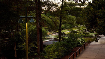
The Leça River Green Corridor spans a total of 42 km and is located in the Porto Metropolitan Area in Portugal. Currently, the river and its banks reflect a long period of environmental and landscape degradation.
The project corresponds to the first phase of intervention and extends along the banks of the river, with a total span of 18 km, of which the first 6 km have already been built. It’s a river that traverses a landscape heavily affected by urban sprawl.
The project’s main goals are: a) creating public spaces along the riverbank; b) restoring the environmental condition of the river; c) improving the landscape quality; d) promoting biodiversity; and e) ensuring smooth mobility and connections with major urban centers.
In this first phase a comprehensive set of measures has been implemented, including the acquisition of private land, water and soil cleaning actions, consolidation of riverbanks, reforestation efforts, reduction of pollution sources, and ensuring connectivity between the pathway and public transportation. These initiatives contribute to the preservation and revitalization of the ecosystem, ensuring the long-term sustainability of the Leça River landscape.
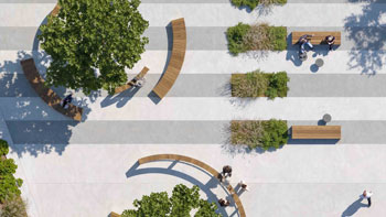
A significant focus of the Green Corridor project is improving mobility and accessibility within the region. It provides safe and convenient pedestrian and cycling pathways that connect urban centers and various facilities such as schools, industries, and large service areas. These pathways offer shorter routes and ensure seamless interconnections with public transportation, particularly the metro/tramway system. By prioritizing active modes of transport, the project aims to promote a healthier lifestyle and reduce reliance on private vehicles, thereby contributing to a more sustainable urban environment. To ensure the safety and comfort of users, the project adheres to specific design guidelines, incorporating a 4m wide mobility lane that facilitates smooth and uninterrupted movement along the corridor. Additionally, four new pedestrian bridges have been constructed to facilitate cross-river access, while existing bridges are integrated into the path, enhancing connectivity and continuity throughout the corridor.
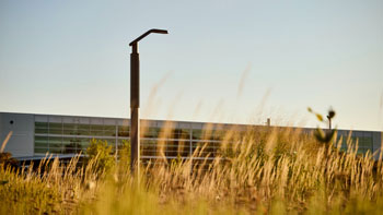
The connection, preservation, recovery and purification of fundamental elements such as water, air, soil, and biodiversity are ensured through the renaturalization of the riverbanks incorporating riparian forests. Along the river native species are planted and hydroseeding of pioneer species is employed to prevent soil erosion, particularly during floods. The vegetation also establishes connections with urban parks, agricultural areas, and forests, which are key elements in promoting biodiversity. Some of the species promote phytoremediation improving the water quality.
The project represents a holistic and sustainable approach to urban development, working with the landscape affected by urban sprawl to incorporate a diversity of experiences in naturalized space, while also considering agricultural and forestry cycles. Furthermore, the Green Corridor establishes a connection between naturalized spaces and heritage elements.
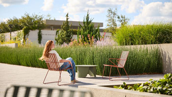
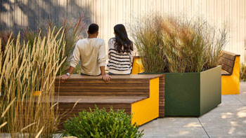
The project also aims to encourage recreation and environmental education integrating different land uses, providing opportunities for observing fauna, flora and seasonal dynamics of nature, as well as agricultural and forestry activities. A diverse environment can be experienced and appreciated along this stretch. This approach allows for the development of narrow corridors as well as expansive areas, depending on the constraints and characteristics of each location.
The project provides a cohesive and enriching experience for residents and visitors alike, seamlessly blending nature, culture, and history. It establishes a significant park-like space in close proximity along multiple municipalities offering abundant recreational opportunities and fostering a bond between nature and communities, connecting the mountains to the sea and rehabilitating degraded areas.
Since its opening to the public many people have been using this route for their daily commutes, either from home to work or from home to school. Additionally, employees make use of their break times to go for walks with colleagues, promoting well-being in the workplace. On weekends, it is common to engage in sports activities, leisurely walks, family gatherings, and picnics along the corridor. Furthermore, numerous volunteer actions have been developed, particularly focused on cleaning the riverbanks, tree planting, and bird identification. Schools and universities organize visits, and thematic tours are also regular activities for the population.
It can be said that the interventions carried out within the project have triggered a process that involves technology and science from various fields of knowledge. Above all it has motivated all citizens to participate in the revitalization of a river that is considered to belong to everyone.


Project team
Coordination and Landscape Architecture: LR | Arquitetura Paisagista
Earthworks and Hydraulic: Iperforma
Structural Engineering: CCAD
Electrical Infrastructure: Auditene
Natural Engineering: Engenho e Rio
Supervision: Câmara Municipal de Matosinhos, Câmara Municipal da Maia and Iperforma – Gaspar Freitas
Construction team
Contractor (Matosinhos): Extraco
Contractor (Maia): Cebrial
Location: Municipality of Matosinhos and Municipality of Maia, Portugal
Design year: 2015-2019
Year Completed: 2022
44512
LILA 2026 Sponsor