LILA 2019 Ex-Aequo Winner in Public Landscapes
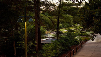
Scenic Path Along Igualada’s Old Gypsum Mines
www.batlleiroig.com
Public Landscapes / Public Landscapes / Spain / Built in 2018 /

![The project for the refurbishment of L’illa Diagonal’s open spaces revisits the original project through a contemporary and respectful approach. The intervention introduces the Umbracle, improvements to the gardens, and interior updates that reinforce the project’s original principle: the permeability of the urban ensemble. In 2018, L’illa Diagonal launched a competition to redesign and upgrade […]](https://landezine-award.com/wp-content/uploads/2026/05/00_77136-Refurbishment-of-Lilla-Diagonal-in-Barcelona-Hero_image-600x507.jpg "Refurbishment of L’illa Diagonal in Barcelona")
![Nestled between the Pyrenees and the Costa Brava, the comarca of Osona is a land of contrasts and quiet beauty. With its fertile plains, winding rivers, and surrounding mountains, the region offers an extraordinary tapestry of natural landscapes and cultural heritage. This rich environment is the foundation for the “Osona Viewpoints Network” (Xarxa de Miradors […]](https://landezine-award.com/wp-content/uploads/2025/05/00-1073-batlleiroig-xaxa_miradors_osona-©Fernando-Mari-HERO-600x450.jpeg "Osona viewpoints network by Batlleiroig")
![The Rambla Girada in Vilafranca del Penedès was constructed in the late 1990s as the central axis of a new neighborhood. It was conceived as a classic thoroughfare primarily intended for pedestrian strolls. The circulation of private vehicles and the arrangement of parking spaces were situated close to the facades of the buildings, leaving a […]](https://landezine-award.com/wp-content/uploads/2024/05/00-1099-©batlleiroig-DRB-2022-Rambla_Girada-600x491.jpg "Rambla de la Girada in Vilafranca del Penedès")
![The Impluvium of Esplugues de Llobregat emerges with the aim of establishing a model for responsible water management and acting as a catalyst for biodiversity in a strategically located area, at a major road junction providing access to the city. The chronic traffic congestion at Rotonda Elisabeth Eidenbenz, compounded by the development of the Finestrelles […]](https://landezine-award.com/wp-content/uploads/2024/05/00-841-batlleiroig-Impluvium_Esplugues-©DELRIOBANI-600x600.jpg "Impluvium in Esplugues de Llobregat")
![The Biolake project unfolds within the expansive canvas of Igualada’s Central Park. It stands as a strategic enclave, solidifying Igualada’s Green Ring and its verdant infrastructure, composed of meticulously crafted open spaces designed with sustainability at their core, both within the city and its outskirts. Nestled within this green sanctuary, amidst the bustling urban fabric, […]](https://landezine-award.com/wp-content/uploads/2024/05/00-841-batlleiroig-Biolago_Igualada-©DELRIOBANI-600x385.jpg "Biolake in Igualada")

![The Boca de la Mina promenade is located in the northwest of the city of Reus, specifically in the north of the railway line and the train station. The walk has been and is an important recreational space for the inhabitants of the city. Its arrangement in relation to the nucleus, the morphology, the gentle […]](https://landezine-award.com/wp-content/uploads/2023/05/00-batlleiroig-BIR-968-boca-mina-reus-碗ordi-Surroca-01-600x600.jpeg "Boca de la Mina Promenade in Reus")


![The Insect Hotel is an artificial shelter and a hibernating place for insects and arachnids made with natural materials. It consists of a divided structure of several sections with nesting facilities. Vulnerable species (such as the solitary bee) can settle into it to develop and reproduce in a comfortable and secure space. The Hotel is […]](https://landezine-award.com/wp-content/uploads/2018/04/Batlleiroig_Insect-Hotel_Main-Picture-600x338.jpg "Insect Hotel")
A beautiful and extremely subtle design, Scenic Path is a gesture drawn so as to offer a discovery of ‘what is already there’ and ‘what has been there’ a long time ago. A clever, precise design of a path, with a sophisticated geometrical set of shifting positions, where platforms, seats or walls organize the views far away, and with the same movements build a very strong sense of place. The materiality of the realization continues and reinforces the design with a great coherence, forming this precise architectonic play with a restrained number of materials. A presence arises – a collision of space and time – and you experience a landscape at the same time very old and very new.
- from the award statementsThe project is set within the broader scheme of the Igualada Green Ring, the aim of which is to generate a series of itineraries for pedestrians and bicycles in the form of a green belt around the city’s perimeter. In this context, the Path along the Old Gypsum Mines represents the recovery of a stretch of 1.65 kilometers, out of which the first 800 meters have now been completed.
The natural space through which this track runs lies on the northern limit of the city of Igualada and is in a very run-down condition. Intense mining was carried out in the site and, when the mines closed down, the area was used as a municipal waste transfer station. In the late seventies, when this facility was also closed down, the space was totally abandoned with no subsequent corrective action or recovery.


The condition in which the space was left presents various issues: the alteration of the original topography has led to slope failures and landslides due to the loss of superficial vegetation coverage and the absence of runoff control measures. Water accumulates quickly and intensely at certain points, creating progressive damage. In addition, the rock walls where gypsum was formerly mined present steep unstable slopes and often cause small rock falls.
However, despite their run-down state, they also have many possibilities. The most obvious is the raised position of the entire itinerary above the city, granting a great potential as a path with a scenic viewpoint, overlooking the city and the mountain of Montserrat. Apart from that, there are still small areas of the original pinewoods that have withstood the various activities carried out on the site. These original vegetation remnants have to be maintained and enhanced. Finally, the
complete abandonment of the area gave way to an incipient productive activity that has colonized part of the sector with a plantation of olive and almond trees.
The project has two principal objectives: one of them aims for a better connectivity, to ensure the continuity of the city-scale project (Green Ring), and the other one seeks the landscape and biodiversity recovering, establishing the necessary elements to generate a new dynamic in the site that will gradually improve its environmental conditions by harnessing the water. In this sense, the proposal creates a section with three clearly differentiated strips that adapt to the different situations of the layout, addressing the problems of the site as well as developing its potential.
The inner edge of the track, acting as a plant ditch, helps to channel runoff from the mountainside and generates a safety strip to stop minor landslips. These same fallen rocks are used to build a sequence of retaining walls with the aim of filtering and re-channeling much of this water to new points where vegetation has been planted to colonize the place. The same elements used to build the lineal benches in the rest areas are also used lower down to create spillways, allowing the water to continue its course in the event of heavy rain.
The central strip, with the main granitic-sand track, guarantees the continuity of the Green Ring. It is approximately 3mt wide and it’s mostly laid out following the original path.
This track is complemented by a third strip, in the form of a linear lookout overlooking the city of Igualada. This vantage point is materialized by a 1-2 meter-wide paved strip along the outer edge of the track, directly related to the views. It is built with hard paving, giving the track a strip with improved accessibility. In addition, the concrete used is made with luminescent aggregate that improves visibility during the evening by returning, in the form of luminescence, the solar energy captured during the day.
The layout of this linear scenic viewpoint recognizes the principal existing landmarks, vegetation and trees by widening and creating rest areas, complemented with linear benches. Finally, this intervention recognizes the exceptionally fine views of Montserrat, generating a final vantage point in the form of a structure cantilevered over the mountainside.
Role of the entrant in the project: Author
Project location: Igualada, Barcelona
Design year: 2016
Year Built: 2018
LILA 2026 Sponsor