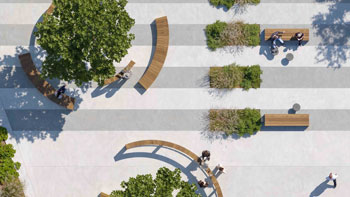
Transformation of Kleinpolderplein, Rotterdam, by Diekman Landschapsarchitecten
diekman-landschapsarchitecten.nl
2025 Entries / 2025 Revisited Landscapes / Netherlands / Built in 2009 /

![In Lemmer is a Friesian Stelp farm that was in operation as a dairy farm until the early 2000s. The business was no longer profitable and the farm and stables were sold. The farmhouse has been beautifully converted into a residence by Onix architects. The design gave new meaning to the farmhouse while maintaining its […]](https://landezine-award.com/wp-content/uploads/2025/05/00-Garden-stelpboerderij-Lemmer-600x450.jpg "Landscaping Converted Stelp Farm Lemmer by Diekman Landschapsarchitecten")
Transformation of Kleinpolderplein
A square that provides nature and water compensation and water storage.
Innovation Award Beautiful Netherlands 2009
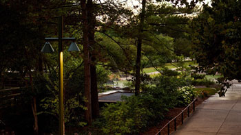
In the 1960s, Kleinpolderplein was built as part of the Rotterdam Ring Road. It was the first major traffic interchange in the Netherlands built in 1960. The square forms the connection between the A20, the A13 and the connection to the city. Although nothing has changed about the interchange since its construction, the future looks completely different.
In fifteen years there will be new highways around Rotterdam, making Kleinpolderplein (KPP) a “city road” again and providing access to the center of Rotterdam. Blijdorp Zoo will have expanded and the Overschie neighborhood will have been completely restructured. This plan anticipates this dreamed-of future.


Before the 2009 transformation, the world below the junction does not yet have a clear identity. Everything runs into each other, intermingles, and the whole area looks cluttered. Used by the Department of Public Works for storage, the square is characterized by paving, the lack of planting, different types of fencing, guardrails, poorly maintained noise barriers and the lack of clear boundaries and a clear language of form. It is a forgotten place.
Commissioned by Stadsontwikkeling Rotterdam, a design for the square was realized that gives shape to the function of the square as an important city entrance with its own identity and image quality and also meets the need for water compensation and water storage which Rotterdam, like many large cities, lacks. With this, one of the first water squares in the Netherlands was realized in due time, a place where ecology also has a chance to develop through its design.
Design.
The concept of the plan harkens back to the original landscape. Over the years, the city has “rolled out” over the landscape, so to speak. When the topographic map of 1850 is juxtaposed with that of 1910, it can be seen that urbanization took off during that period. It is this urbanization that largely causes the water problem.
In the plan, a piece of the original wetland landscape has been “flown in.” This has created a representative and “natural” place.
The quay of the water is designed in the form of the logo, “the icon” of Rotterdam: the Meuse. In the water square, the icon is also visible. The whole water square has a water storage of maximum (1000 m3).
Museum Room- Water Square:
The water square is dry most of the year. This place is sunken and functions as water storage during moments of heavy rainfall. To give more allure to this square, which is quite dark due to the A13 overhead, the square is set up as a museum room for Rotterdam’s orphaned sculptures. The square features several works of art on pedestals. These pedestals are inspired by the visible foundations of the A13. Above each pedestal hangs lighting. In this way, the lighting of the entire square has been solved in a functional way.
The low moorland:
The new landscape, the low moorland below the junction, refers to the original landscape. Part of the planning area has been paved. The original porphyry boulders have largely been used for this purpose. These paradoxical worlds, the low moorland area and the paved part of the plan, are connected by a recognizable line, the icon of Rotterdam: the Meuse.
The low moorland is fed by the existing water circuit and water square. Large culverts have been constructed to the plan area that are connected to the water circuit of Overschie. Overschie has a new water surface that is functional in the entire water system making the water in the plan area flowing water. The quality of the water is thus largely guaranteed.
Low bogs develop because systems are fed by rainwater and surface water. This water is allowed to be relatively nutrient-rich. At the start of the project, the final image was simulated. For it to grow spontaneously takes a long time. It will take its shape and biological balance over time.
The occurring tree species in the original landscape are alder and birch. The herb layer includes summer forget -me-not, camp grass, woodland hawkweed, bog buckgrass, marsh spurge. In addition, reeds are very iconic.
For the purpose of nature development, different types of steepness have been incorporated into the edges of the low moor. This increases the diversity of flora and fauna. It has created opportunities for good development of flora and fauna.
Other credits:
Rijkswaterstaat; Hoogheemraadschap Rijnland; Stadsontwikkeling Rotterdam
Ecologie Sjef Janssen
Fotografie Rene Mesman
Kunstobject Observatorium
51°55'53.4"N 4°26'16.7"E
63283
LILA 2026 Sponsor